National Geographic United States Map - Folded, Waterproof, Tear-Resistant with Flags & Facts
Product Description
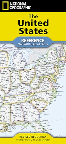
Discover the rich geography and fascinating details of America with the National Geographic United States Flags & Facts Map. Meticulously researched and expertly designed, this authoritative reference map is an indispensable tool for students, educators, travelers, and anyone eager to explore the diverse landscapes and unique heritage of the USA.
Crafted for exceptional durability, our U.S. map is engineered to withstand frequent handling. Say goodbye to flimsy maps that tear or smudge; this edition boasts a premium, high-quality material that is both waterproof and tear-resistant. Whether it's spilled coffee in the classroom or repeated folding in a backpack, your National Geographic map will remain pristine and ready for countless adventures.
Go beyond basic geography! This comprehensive map doesn't just show you where things are; it educates and inspires. Each of the 50 states is beautifully depicted with clear, precise cartography, highlighting capitals, major cities, national parks, and key geographical features. But what truly sets it apart are the dedicated sections for every U.S. state flag and a wealth of engaging facts, offering a deeper understanding of each state's unique identity.
- Unmatched Durability: Constructed from advanced waterproof and tear-resistant material, ensuring long-lasting use without damage.
- Comprehensive U.S. Coverage: Features detailed cartography of all 50 states, including capitals, major cities, national parks, and geographical landmarks.
- Educational Flags & Facts: Learn about each state with vivid illustrations of its flag and fascinating, concise facts.
- Trusted National Geographic Quality: Authored by world-renowned cartographers, guaranteeing accuracy and unparalleled detail.
- Convenient Folded Format: Designed for easy storage and portability, making it perfect for home, classroom, office, or travel.
- Versatile Learning Tool: Ideal for students, homeschoolers, teachers, travelers, and anyone passionate about American geography and history.
Perfect for classroom presentations, homework assignments, travel planning, or simply satisfying your curiosity, the National Geographic United States Flags & Facts Map is more than just a map – it's an engaging educational resource. Bring the wonders of American geography and civics directly into your hands with this durable, informative, and beautifully presented reference guide.